Sunday, December 30, 2007

Leadership


Likeability Is not a Necessary Qualification for Leadership. A New Year is about to begin. Anguilla looks forward to progress on constitutional reform. The British Government demands we consider the issues and tell them what we want. Anguillians demand constitutional advance. Government cannot keep putting off taking a decision. Anguilla is already one of the laggards in this Overseas Territory’s endeavour. General elections in Anguilla are only a couple of years away at most. We must have our new Constitution by then. It would be a disaster to put it off until after the elections. The Chief Minister has promised that once the New Year begins we will go back to considering constitutional reform. We have dithered away all of last year. We cannot sensibly continue in this way.

The Chief Minister is in a quandary. He established a committee to advise him and to assist government in negotiating constitutional advance with the British. The committee has presented him with a problem. He cannot get all the members to agree with each other on the way forward. He has two different streams of advice coming out of the committee. They are irreconcilable.

There has been public discussion on the various constitutional issues for the past several years. Some members of the committee contend that a consensus has emerged. They say that that consensus is embodied in the Report of the Constitutional and Electoral Reform Commission delivered to government in August 2006. They believe that this Report contains the true voice of the Anguillians. However, not every Anguillian contributed to the discussions and to the eventual Report. There were some who “boycotted” the process. They form the second group in the Chief Minister’s committee. They argued at the time the Commission did its work to the effect that it was the responsibility of the British under various United Nations resolutions to educate the people of the Overseas Territory on the options open to them for Constitutional advance. This group argued that until the British had discharged this “duty”, Anguillians would be incapable of knowing what they really wanted in terms of Constitutional advance. They insisted that we must first go through a process of being educated by the British before we could sensibly make up our minds. No one would have a problem with the proposition that we should educate ourselves. The problem most of us had was that it was said that it was the responsibility of someone else, the British government, to do the educating for us! This group claims that the Report does not represent the true vision of the Anguillians for Constitutional reform. They insist that any reform process based on the Report is flawed. They demand that the reform process begin all over again. They waited until the process of consultation and drafting of the Report was completed. Then, they put the spanner in the works. They refused to accept the Report as the basis for going forward with reform. They have gone further. They insist that the only way that we will know if Anguillians are in favour of any proposed constitutional advance is if there is a referendum.

The two groups will never agree. They are not capable of coming to a consensus. Someone has to cut the proverbial knot. It will be a demonstration of leadership when those who must lead finish listening to the two contending streams of advice, and then come to a decision on how best to proceed. The decision when taken will not please everyone. Some will be happy with it. There will be others who will be upset. That is one of the responsibilities of leadership!

Should a leader want to be liked? Yes, of course. We all want to be liked. None of us wants to be disliked. But, should a leader abdicate leadership because he is not sure whether what he decides on will be appreciated? Does one show leadership when one puts off taking a decision because one does not have consensus? Does a real leader duck the responsibility of leading the way until he has everyone agreeing on the same direction? Does the helmsman seek consensus and approval from the rowers?

To ask the question is to provide the answer. A good leader will study the issue carefully. The leader will take advice from persons who are pro and from those who are con. A good leader will not demand consensus among his advisers. The real leader asks for a variety of opinions. The real leader does not fail to take a decision because the decision will not be approved by some. That is to abdicate leadership. We know real leadership when we see it. It is shown by the person who goes out in front and says, “Follow me”. It is shown by the person who takes a stand, based on principle, and summonses the followers to the cause.

Who likes it is a question asked by the politician. The statesman does not even consider asking the question.

Or, as my late Dad used to say, “Who vexed, lose!”


Saturday, December 29, 2007

Christmas


Compliments of the Season.

Here’s hoping we all had a Happy Christmas!

I know we all look forward to a Prosperous, Safe, and Healthy New Year!

Sunday, December 23, 2007

RSPB-BOTs


Submission of the Royal Society for the Protection of Birds to the Foreign Affairs Committee on the British Overseas Territories. It is a regrettable fact that we Anguillians are too caught up in our daily activities to give much thought to where Anguilla is going. Yet, there are no other persons who should be more concerned about our environment, and plans for the future economic development of our island, than we ourselves. Commentators such as Dame Dr Bernice Lake, Colville Petty and Lolita Davis Richardson have been lamenting over this paradox for years. Nearly everyone else is silent.

The very concept of discussing where Anguilla is going is difficult for most islanders to grasp. There is no point writing about the issue. Anguillians, it is said, do not read. Some who genuinely care try to stir up local enthusiasm by making a foreign conspiracy out of the subject. So, we hear from the soap box that if Anguilla is going downhill, it is due to a secret British plot. The object is to drive Anguillians off their land. Anguillians must be permitted to over-develop the island in order to destroy its culture. This is intended to permit the British ex-pats to take over. They want to repopulate the island with hordes of semi-skilled Glaswegians and Cockneys. They are all just dying to give up their homes and move to Anguilla. So goes the theory. You will hear it whispered all over the island.

The hard evidence is entirely to the contrary. It is xenophobic rubbish. A little research indicates that there are more British individuals and organizations than Anguillians worrying over where Anguilla is going. It took the House of Commons Foreign Affairs Committee to begin an examination into how Anguilla is governed. They called for interviews and submissions. The RSPB filed a submission. This is something that I am not aware any individual or organization from Anguilla has yet done. It is the most accurate description yet of where Anguilla is going that I have read. The RSPB points out that Anguilla’s natural environment is under threat. This has been caused partly by a failure to implement systems of effective local government. The rate of tourism development is increasing rapidly. The natural assets which attract visitors to the island are in danger of being destroyed. Areas, such as Sombrero Island, that have been previously proposed for protection, are still not approved by the Government. Protected areas that have been approved are in the process of being degazetted. Our legislation does not require that development plans and proposals undergo an Environment Impact Assessment. Where an EIA is called for, there is inadequate expertise or capacity to accurately assess the Assessment produced by the developer. Decisions are made without consideration of the information in the EIA, or even of the government experts’ own comments on it. EIAs are frequently difficult to access, and are rarely shared with the public. Planning procedures are not transparent, and do not engage with civil society. Government frequently gives assurances to developers that, no matter what adverse indications turn up in the EIA, the project will nevertheless be approved.

As the Submission points out, our capacity to implement effective environmental governance and respond to environmental crises is constrained by limited human and financial resources. The Environment Department and the Anguilla National Trust only have small numbers of staff that are stretched very thinly. As ANT relies to a significant extent on funding from government, it is not able to respond objectively when consulted on development proposals. It would be threatened with budget cuts if it dared raise objections either loudly or effectively. ANT’s officers are principally government civil servants steeped in a culture of not rocking the boat. The Anguilla Archaeological and Historical Society is all-volunteer, but it suffers from all the symptoms of old age, and does not function any longer.

As our natural environment continues to deteriorate, government appears to be taking little or no action to remedy this. Our lack of capacity, coupled by the lack of interest or support from the UK Government on these issues, means that the deterioration of our ecosystem continues largely unabated. The Anguilla government needs to provide sufficient resources so that we can implement similar environmental standards as they have in the UK and Europe. We need to put a greater proportion of the revenue we raise from our environment into locally established environmental funds and systems. Expenditure must be transparently linked to the purpose for which the funds were originally raised.

I don’t know why I bother to post this. A sense of frustration with government’s failings overwhelms. The problem is not limited to government. It extends down to the village level. No one in Anguilla who counts cares. No one in Anguilla who cares counts. So it has always been and so it seems it will always be. Emile once told me that it would be political suicide for his government to attempt to introduce fisheries regulations to control the activities of our fishermen until they had killed the last fish. He was right. I fear that the same rule applies to our environment and to our economy.


Friday, December 21, 2007

AARF Critical


Anguilla Animal Rescue Foundation Criticises “Dolphinarium” Blog as Irresponsible. AARF is Anguilla’s premier animal protection society. It looks after any animal in distress. It reports to the authorities on acts of cruelty to animals. It should have a deep and abiding concern for Anguilla’s dolphins. Those whose principal interest lies in little puppies and pussies should not be contending with those more concerned with the plight of our endangered iguana or the holding in a prison in Anguilla of eight dolphins. They have a common cause. They should be natural allies. They should not be attacking each other’s efforts on behalf of dumb and helpless animals. That causes a waste of energy and a loss of focus. So, imagine my concern, if not consternation, when the following press release dated 18 December was given to me today.

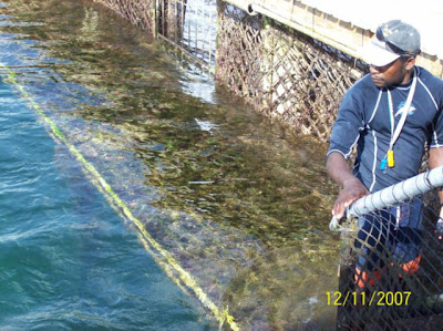
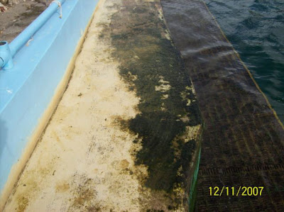
It was only on 16 December that this blog broke the story on the deplorable condition in which the dolphins were then held. Photographs taken on 11 December were shown. It was hardly an irresponsible coverage. The evidence was there before all our eyes. Now, officers of AARF have visited the site. It was two days after we reported the story here. They say they found the dolphins “in great shape and extremely well cared for”. They saw what they saw. They wrote what they wrote. They say they “cannot condone irresponsible press releases”. They condemn those “who wish for an animal to suffer and die in order to attract public attention”. This critique must refer to the blog of 16 December. There was no other press release on the subject. Unless it is Nat Hodge’s news article in Thursday’s issue of The Anguillian newspaper. He published some photographs that were not on my blog. I assume he had access to the person who took them and to those who visited the site then. He wrote his own story, and did not quote mine. He wrote, “Though not in colour, these photographs present a gruesome reality of the environment of the captive dolphins”. Enough said about conditions at that date.

Let us leap forward to today 21 December. By coincidence, one of my correspondents visited the site today. My correspondent took more photographs. Let us look at them and determine for ourselves what they show.

This is a shot of the outflow pipe onto the beach. It shows that the pumps are not running today. I accept that they must be capable of running to have been able to top up the tanks that are shown in the photographs of 11 December. It is very costly to run the pumps all the time.

This one shows the algae oozing out of the dolphin tanks. If this is what comes out of the discharge pipe, the water can hardly be described accurately as clear and with the pens clean. One has to ask how the government vet who helped write this press release could have reported to the executive committee of AARF that “he had visited the facility earlier in the month and reported to us at that that time, that the water was seen to be clean, no chemicals were in use, the water circulating system was working . . . This is shown by the photographs taken in early December, and earlier published, not to be true.

This photo shows scum and debris floating on the top of the water today. Did it all grow back since the visit of AARF on 18 December? It is difficult to see how so much algae could have grown in the few days that had passed. Did AARF miss it on their visit?

There were originally eight dolphins on the site. There are only two visible in the tank at this time. At any rate, only two were alive and well enough to swim around and show themselves today when these photographs were being taken. I am told that in the dead of the night last night, a cargo plane flew in to Wallblake Airport and, with the assistance of the local customs and veterinary authorities, four of the dolphins were shipped off the island. We are told they are going temporarily to Tortola. So, there should be four dolphins left in Anguilla. Does anyone know what happened to the apparently missing two?

The water level in the above photograph is higher than the level shown in the photographs in the post of 16 December. The tank has obviously been topped up recently. My correspondent writes me that you have only to look into the water and you can see that while the surface of the water is relatively clear, the muck on the bottom has not been removed. It is as filthy as it was before. My correspondent’s exact words are, “I shot views to show that the water level is back up to par. It appears to me that the tank has been cleaned "cosmetically" around the edges as when I looked hard into the bottom of the tank I could see clumps of algae, etc.” It would appear that after the story broke, the dolphin people hurriedly turned back on the pumps and topped up the tanks. They did a little surface cleaning, no more than that. If the missing two dolphins are still there, it means that the water is too dirty to see them.

Those in Anguilla who do not understand what all this fuss is over “a bunch of fish” must be laughing.

I am ashamed of AARF.

EU-OCT


Relations Between the Overseas Countries and Territories and the European Union. In a recent article published in MercoPress we learn what our leaders were doing, or not doing as the case may be, on our behalf in their recent meetings in London. These meetings were held in the last week in November and the first week in December.

The article concerns the November meetings. The information comes in a release from Mike Summers, one of the representatives of the Falkland Islands. We wish that all our leaders in the OTs were so open. It does not strike any of us in Anguilla as odd that we have to go to a newspaper published in Montevideo, Uruguay, to learn about meetings between the Overseas Territories’ representatives and the representatives of the European Union.

The representatives of the Overseas Territories took the opportunity to meet to discuss the composition of a paper reviewing our relationship with the European Union. This is important because increasingly in the years to come the European Union will pass laws that are going to apply to us in the Overseas Territories. They have already begun to do so in tax and trade matters. We need to have a unified position if we are to be able to defend ourselves from any onslaught on our liberties by the Europeans.

There has not been a word about these meetings in any press release on the website of the Government of Anguilla. Not a word in The Anguillian newspaper. A Government press release on the various social events attended by the Anguilla team while in London suggests that this aspect dominated their time.

One feels justified in concluding that our leaders are convinced that the less we know about Europe’s plans for us, the less trouble we can be to them.

Of course, it could just be that none of our team from Anguilla bothered to attend the November meetings. Maybe, they know nothing about these developments. If this is so, in my view, it will prove to be very unfortunate for us!


Wednesday, December 19, 2007

Legal Aid


The Anguilla Legal Aid Clinic. ALAC is a service offered by the Anguilla Department of Social Development. The Clinic operates three mornings a week, Monday, Wednesday, and Friday. Any person can telephone the front office at 497 2317 and make an appointment. There is a simple Intake form that the client is required to fill out, giving some personal background information. There is an administration charge of EC$10.00. That is it. The attorney will see the client and offer advice on whatever the problem is.

Sanford Richardson is the Director of the Department. When the idea for offering the service was first put to him, he jumped at it. Dr Bonnie Richardson-Lake is the brave Permanent Secretary who took the project to the Hon McNeil Rogers and got it officially sanctioned. First Kishana Rogers, and now Janique Richardson, act as the initial contact at reception. All the staff in the Department have been kind and generous with their time and advice. Several lawyers have taken clients as either pro bono cases or at greatly discounted cost. Thomas Astaphan of Astaphan and Associates, Eustella Fontaine of Caribbean Associated Attorneys, Ricki Camacho of Joyce Kentish and Associates, Cora Richardson Hodge, and Keesha Webster have all provided excellent services to the clients of the Clinic. For this we thank them.

The majority of the problems brought to the clinic fall in the area of family law. These range from child support and custody cases, to adoption and divorce. Family law is closely followed by criminal law. These involve visiting the prison to consult with and advise mostly juvenile offenders. Probate and administration questions compete with land disputes for attention. All in all, it is just like a normal legal office.

The Clinic is just one year old last month. I am inordinately proud of it. But, I missed its birthday celebrations!


Sunday, December 16, 2007

Dolphinarium


The Present State of the Dolphinarium. The Dolphin Discovery facility at Meads Bay is closed down. It appears to have been abandoned by the previous management. There seems to be only a handyman present on the site during the day. He tries valiently and without management guidance to keep up with basic maintenance. The dolphins are left to swim in their own waste. The water has become badly polluted. It is now in what must be a dangerous state for the health of the dolphins and anyone else, for that matter, venturing into the water.

The relevant authorities are in the process of deciding whether to permit Dolphin Discovery to move to a new site at the Sandy Spit at Blowing Point. They are said to be going to make an independent judgment. They will consider the track record of these people and they will study the Environment Impact Statement presented to them by Applied Technology and Management Inc of West Palm Beach, Florida, and dated November 2007 [link here]. I thought I would help you to see what the authorities will find when they consider the present facility in conjunction with what the EIS says. This is a sort of photo-essay. It is only a few of the photos that were sent to me. Each has as its caption a quote from the EIS.

EIS, page 22: Dolphin Discovery currently operates an existing facility on Anguilla at Meads Bay, an operation that has been a substantial contributor to the tourist-based Anguilla economy.”

EIS, page 1: The Developer has demonstrated that they will ensure the animals’ welfare and veterinarians will monitor the dolphins’ health and provide appropriate care.”

EIS, page 17: Ongoing observations will occur daily by both the behaviour and medical staff. . . . The Dolphin Discovery project will employ numerous highly qualified professionals with experience in the area of marine mammal care. . . . All relevant staff members will be trained on animal evaluation, including diseases, pathogens, and injuries that are known to occur in captive bottlenose dolphins.”

EIS, page 40: Fish and other aquatic organisms depend on dissolved oxygen (DO), which is the oxygen present in water, to live. . . Dissolved oxygen can drop to dangerously low concentrations in water bodies that are very warm and/or have an excess of organic matter. Organic matter can originate locally via large growths and subsequent deaths of living organisms (oftentimes phytoplankton responding to an enrichment of nutrients), or organic matter can originate elsewhere and enter the water body via waste water treatment plants, failing septic tanks, and agricultural and urban runoff.”

EIS, page 17: Cleaning, food preparation and personal hygiene procedures such as hand washing and the use of footpaths will be taught to each staff member.”

EIS, page 19: All food preparation equipment (including buckets, sinks, scales, etc) and facilities will be cleaned and disinfected daily or more often as needed. The project will follow the US Department of Agriculture’s regulations for preparation of food.”

EIS, page 20: The wastewater collection and transmission systems will transport the wastewater via gravity in order to minimize the use of pumps and mechanical equipment which require additional maintenance and power.”

EIS, page 20: The wastewater collection system will be designed to handle estimated peak hourly flow conditions such that even during peak conditions, the wastewater will be transported away from the event/entertainment areas in order to eliminate any potential nuisance from overflows and backups in the system.”

EIS, page 25: Legislation in Anguilla regarding environmental management and conservation is limited.”

EIS, page 27: Legislation pertaining to waste disposal and noise quality and pollution is very restricted and would not apply to the present development.”

EIS, page 27: There are no local standards for dolphins that are kept in captivity that apply to this project. The Developer will comply with accepted standards for other Caribbean nations as presented by the Government of Anguilla. Minimum suggested standards to use are the human swimming water quality criteria used in the state of Florida. Secondary guidance from similar facilities such as in Ocho Rios, Jamaica, include ensuring that the water quality criteria that are maintained are within human criteria as these are considerably more stringent than those established for dolphins.”

EIS, page 41: In marine waters, particularly those of the Caribbean, nutrients are present in low amounts. When they become available in large quantities in surface waters, they can cause excessive growth of algae and other plants.”

EIS, page 42: Total Kjeldahl nitrogen (TKN) is the sum of organic nitrogen and ammonia in a water body. The measurement of TKN can indicate the origin of nitrogen loads. For example, high measurements of TKN typically result from sewage and manure discharges to water bodies.”

I don’t think it would be unfair to say that Dolphin Discovery has provided government with all the evidence it needs to determine the commitment of these people to maintaining the highest health and animal care standards at their Anguilla facility. Let us hope government will make their decision based on the evidence.

Saturday, December 15, 2007

FAC


The Foreign Affairs Committee. The FAC, about which I have previously written [link here], has begun its consultations. Our Chief Minister met with the Committee during the recent meetings in London. I was particularly impressed with the following answer to question 104:

Q104 Chairman: You are only the Chief Minister?

Osbourne Fleming: I am only that and I delegate and I leave the guys to themselves. However, we are doing well financially. When you consider our geographical position, we are edging up. Our offshore services are slowly coming up. I am glad that the Minister of Finance is here: sometimes I get tired of him over there.

To read the testimony for yourself, you might like to click on the following link:
http://www.publications.parliament.uk/pa/cm200708/cmselect/cmfaff/uc147-i/uc14702.htm

Well, what do you make of it?


Friday, December 14, 2007

Non-roads


Roads that Go Nowhere. I want to take you through one last example of a road that is not a road. If you have read the previous three posts, you will know what I mean.

The surveyor's plan that we are going to look at is not chosen because there is anything particularly special about it. I suspect that the same situation that it depicts has been created all over the island. I only pick it because (a) it involves the parcel of land immediately to my north and I am familiar with it, and (b) it has only recently been brought to my attention. Let us look at it.


We are looking at a sub-division of Parcel 6 to the north. You will notice that Parcels 293 and 294 lie to the south of it. This is my property, where I live at North Hill. My mother’s land lies to the east, or right of the plan. You will see a right of way that skirts around my property to the west, north, and east of my land. It is painted red. That used to be a 10 ft right of way that ran through the center of my property. Several years ago, I agreed with my mother that we would relocate the road to where it now lies. We would make it a joint road. It would also benefit my neighbour immediately to the north. She owns Parcel 6. Her land was cut off and had no access to the main road, which lies some distance to the west. My road would give her land access for the first time. I contacted her in St Thomas. She agreed that we should register a joint right of way along our boundaries. She told me who her lawyer was. I prepared the Grant of Easement forms provided by the Land Registry. I sent them to her lawyer to send on to her for signing and to be returned to me for registration. Months passed. Nothing happened. I repeatedly contacted the lawyer. There was no explanation why the forms were not forthcoming. I could not wait any longer to provide my mother with access in case she wished to deal in her property. I registered the forms with my signature and that of my mother. I hoped that in due course my neighbour’s forms would turn up. That is why the right of way to the west and east is 10 ft. That to the north is only 5 ft. It was supposed to be supplemented by the same amount of land from my neighbour. Her forms never turned up and were never registered. She never got a right of access to her land.

Knowing that a five-foot roadway was inadequate, I constructed my fence about 12 feet back from my boundary. I made a 12 ft road all around the property. There is physically plenty of room for a car to pass around my existing fence. That is the road I use to enter my yard.

A few weeks ago, I received a telephone call. My neighbour was outside my fence. She was showing a prospective purchaser one of the lots that Parcel 6 had been divided into. I went out to say hello. I was meeting her in person for the first time. She was there with her surveyor. I learned that the land had been subdivided. I saw the plan above for the first time. I can only describe my reaction as shock and horror. What does it depict?

First, you will notice that the subdivision includes “Lot #6” which is called a “Road”. You will see that it goes the full length of what used to be parcel 6 and even swings around to the west and goes nowhere. It does me no harm. I am not quarreling with it. I do feel sorry for my neighbour. The road is not a road at all! Those of you who are lawyers or surveyors or who have read the previous three articles understand that already. For those of you that are unclear, let me explain.

First, she has not been invited by government to make it a public road. She has not given it to the government. It is still registered in her name. She has not signed a transfer to the Crown. It is not a public road. Neither is it an adequate private road, or right of way. It might conceivably, if grants of easement have been registered in favour of Lots 1-5, provide easements of right of way for one over the other. Though I have not checked, given the sloppy planning here, I seriously doubt if that has been done.

Second, it is not a proper right of way. It does not take the owner of any of these lots to the nearest public road. Even if it had been given to the government, it does not connect to any other public road. It does not connect in law with my private road that runs over my land. Just as I have no right to trespass on the imaginary road called “Lot #6”, so she has no right to pass on my road. She can put up a notice barring me from trespassing on her Lot #6. I could put up a barrier at the corner of my road and block any one from accessing it. We have no rights over each other’s land. This is a road that goes nowhere.

What should have been done should by now have been obvious to you, if you have been reading the previous posts. She, or her surveyor, or both of them, should have contacted me. They should have contacted the other affected landowners. They should have told us of their plans to sub-divide Parcel 6. They should have explained to us that the Land Development Control Committee is insisting that the sub-divisions have a 25 ft access road. I understand from the surveyor that this is what in fact happened. They should have pointed out to us that we had already made provision on the register and on the ground for a road. We might have been asked politely if we would agree to incorporate it into the proposed road that would be shown on the sub-division. There is no reason to believe that we would have objected. My neighbour would have got her 25 ft road. She would have lost .3 and not .61 of an acre. That is more than half an acre. She is selling one of the lots for US$150,000.00. I am no good at mathematics, but I calculate that as a completely unnecessary loss to her of US$50,000.00 in round figures.

And, she still does not have a right of access to her land!

If she tries to sell it to someone who has proper legal advice, the prospective purchaser will be told that the land has no access to a public road. No properly advised person would risk purchasing this land without a registered right of way.

Tell me if you can understand why my neighbour was advised to proceed in this way. Does this make any sense to you?

As far as I am concerned it is a complete fiasco.

What does the LDCC think it is doing?

Does it have a legal adviser who attends Committee meetings, and did the legal adviser study and practice conveyancing law?

Wednesday, December 12, 2007

Access Roads

Unnecessary Roads. We have been discussing the improper registration of rights of way in Anguilla. The day is going to come when the problems that have been storing up are going to explode. Let us hope that they can be corrected before that happens. I want us now to look at one or two practical examples. I have chosen two land sub-divisions adjacent to where I live. This is not because they are particularly special. It is just that I know the persons and the circumstances involved. Also, if any “mistake” has been made, I am not the one who suffered. If anything I, or my family, are the ones who benefited from the mistake. No one can say I am writing this out of any sense of a private grievance. If anything, I grieve for my neighbours who have been taken advantage of for my benefit, unknowing as it was.

Let us take the case of Mr D’s land first. I invite you to study the following plan.


My property is to the east, or far right, Parcel 293. Daryl Richardson, known to everyone as “Mr D” is now deceased. His land lay to the immediate west of Parcel 293. It used to be registered as Parcel 7. My land derived originally from the same Parcel as Parcels 20, 186, 187 and 202, which lie to the south of the rights of way painted blue and red. Let us call it the Owen Estate. Mr D, as the owner of Parcel 7, and the administrator of the Owen Estate, agreed on a mutual right of way running up the common boundary. It was a 10 ft right of way. We have seen in an earlier article that this was the minimum width for demanded by the Chief Surveyor at the time. The Administrator gave Mr D a five foot right of way up the boundary of the Owen Estate. Mr D gave the Owen Estate a reciprocal right over his land. This mutual right of way is shown painted red on the plan above. We registered the grants of easement in the Land Registry.

Years passed. The right of way worked well. One of Mr D’s sons started building his home on what is called “Lot 3”. Another son started his building on what is marked “Lot 2”. Mr D died. He left a will leaving the land to his sons and daughter in the way he had planned it before he died. The Executor hired a land surveyor to divide Parcel 6 and distribute it as provided in the will. The surveyor knew from previous surveys that the Land Development Control Committee now requires a 26 ft access when land is being sub-divided. The result is the plan in front of you. You can see that he made provision for access westwards down to the public road for Lot 3. He has created a separate parcel of land for it, Parcel 267. It starts off on the west at the public road 26 feet wide, and at some point becomes 21 feet wide. All of it is taken from Parcel 6. None of it comes from the Owen Estate. The surveyor was aware of the mutual 5 ft rights of way. He knew that the 5 feet added to the 21 feet would make a consistent 26 ft right of way.

What to me is extraordinary is that no effort was made by anyone to speak to the registered owners of the Owen Estate about widening the mutual right of way. There are only two of them. One of them lives on the land and the other is my mother who lives at Old Ta. The surveyor did not do it, though he is an old friend. The Executor was not told that it might be a good idea. He is my cousin, David Carty. He would have had no difficulty in making the approach, if it had been suggested to him. The surveyor simply made a 26 ft and a 21 ft provision for access out of Mr D’s land. End of discussion.

What is so irregular about this new road? You will have read the two previous articles. We discussed the law and proper practice on public and private rights of way.

First, this right of way is not registered as a public road. So, I cannot use it as of right along with other members of the public.

Second, it is not the subject of mutual easements of right of way. I cannot use it as a private right of way. It is called a “right of way” on the map. Just seeing it on the map does not give me a right to use it. I am perfectly content with the present 10 ft right of way. But, would it not have been better for the heirs of Mr D’s estate if they had negotiated with the two owners of the Owen Estate to share burden of the right of way? They would not have lost so much land.

Thirdly, the new right of way has been made into a separate parcel, Parcel 267. It is completely and fundamentally wrong to create a separate Parcel of land to constitute a right of way. A right of way cannot be a parcel of land. It is a right enjoyed by one landowner over the land of another landowner. The only conclusion I can come to is that it might be a device to block off the land so that one day the government can acquire it freely, without having to pay anybody for taking it for the public use. What is wrong with that? The normal practice all over the world is for the public to pay private landowners for the right to pass over their land. This is accomplished by government paying the landowner for the public right of way. It is only fair.

Finally, what was the use of starting the new roadway to the north of the existing right of way? Just to make a straight line? The existing roadway passed over the land designated and left by the Owens for the purpose of gaining access to the lands to the east. The present owner could have been approached about widening the present roadway from 10 feet to 26 feet. He is a very reasonable person. There is no way that I can see him refusing such a sensible provision. The narrow piece of land to the west of Parcel 186 is not capable of being used for any other purpose than the road for which it was intended. In my view it was completely unnecessary to have taken 26 feet out of the south of Mr D’s garden, while leaving the present 10 ft road just a few dozen feet away!

The surveyors tell me that there is nothing they can do. The survey will not be approved by the LDCC if there is no access. The LDCC has told them to make provision for access out of the land they are surveying. Others tell me that the LDCC has done no such thing. The LDCC has mandated that there must be access when a sub-division is being made. They do not care how it is done. They would expect the surveyors to assist their clients to negotiate with the neighbours and get them to agree on what is fair to all, a mutual right of way along their joint boundaries. If they cannot agree on this in a reasonable time, then the road provision might have to come out of one person’s land. But, that would not be the preference of the LDCC.

I don’t know. Well, what do you make of it?


Monday, December 10, 2007

Roads

Rights of Way. A professional friend of mine commented to me yesterday, “Don, I do not know what the fuss is all about. I am interested in buying a piece of land. The map shows a right of way. Surely, I do not need more than that?”

I can excuse my friend. He is not a lawyer. It is not even every lawyer who has studied conveyancing law. That is the law governing the creation of and dealing in interests in land. Lawyers have been known to make serious mistakes when advising on land matters. So, what is a road or right of way in Anguilla?

A road, properly speaking, means a ‘public road”. This is to distinguish it from a “private right of way”. A public road is governed by the Roads Act, chapter R 65 of the Revised Statutes of Anguilla. So, for example, section 17 declares that every road is to be at least 32 feet wide, with a discretion to the Chief Engineer to make it narrower. That is a public road. By contrast, there is no minimum width for a private road. Indeed private roads are not dealt with by the Roads Act, only public roads. A public road is created in only three ways. One is by ancient use, the other is by grant, and the final one is if I invite government to spend public money on repairing a private road over my land. That is, a public right of way comes into existence only by the public having exercised such a right for a very long period, or if I give or sell the government a public right of way over my land. At common law a public road might exist without the land under it being owned by the government. In Anguilla, the law has been set up so that the government owns the land over which a public road exists.

Private roads are registered in Anguilla as a “right of way”. A right of way over my land is a right. It is not land. When I give or sell you a right of way over my land, you and your guests have a right to use that roadway to access your land. No one else may use that roadway without my permission. It is a private right of way, meaning private to you and me. The public have no right to use it. I can block them off, or sue them for trespass. Private roads or rights of way are registered as easements in the Land Registry under the provisions of section 93 of the Registered Land Act, chapter R 30. Every easement must have a “dominant tenement” and a “subservient tenement”. That is the land that enjoys the right, and the land over which the right is an encumbrance. So, on your Land Register you will find in the “Proprietorship Section” a note that you and I have registered a right of way over my land for the benefit of your land. That means that the road I gave you over my land is not private to you. It belongs to whoever owns your land in the future. The easement belongs to the land, not to the owner of the land. On my Land Register, we will find that there is a note in the “Encumbrance Section” that there is a right of way in your favour over my land. The Registered Land Act requires every interest in land to be registered. If an alleged easement is not registered, then it does not exist. There will be a survey or plan in the Land Registry showing exactly where the right of way over my land is. You cannot just walk or drive over my land anywhere you want. You must follow the exact roadway that I gave you.

Two things should be emphasized. You have the right of way. The burden of maintaining it, or surfacing it, rests with you. If you want to put down marl to make a smooth drive, the cost is yours, not mine. I give you the right to pass. I do not guarantee you a smooth passage! Secondly, you own the right, I own the land. You have no interest in the land other than the right to pass and re-pass in the manner we have agreed. We might have limited the right of way, for example, to passage by walking. That would mean that you have no right to bring a vehicle over my land.

Private rights of way are depicted in the Land Registry by two broken parallel lines. The letters “ROW” indicate that it is a right of way. Next to these letters you will see some numbers between brackets, eg, “20”. This indicates the width in feet of the right of way. So, if you are looking at a piece of land with a view to purchasing it, you look at the Block Map. If it shows a registered private right of way running alongside the land, you ask to see a copy of the Land Register for the parcel you are interested in. You look to the Proprietorship Section. If there is no right of way entered you know immediately that the right of way is not yours. You ask the person selling the land to prove to you that the land has a registered right of way before you buy it. A road on the ground is no evidence that there is a right to use it. A public right of way is shown by two solid parallel lines with the same letters “ROW”. If the land you are interested in has a public right of way leading to it, you will not find an easement registered on your Register. All members of the public, including you, have the right to use that road.

So, when you are dividing up your land, you are expected by any good planner to provide access for all your subdivisions. You cannot cut off some in the back without giving a right of way over one or more of the parcels to the nearest road. Problems arise in Anguilla frequently when the Planning Department tells you to provide a right of way. I have mentioned this in the previous article. You will realize by now that there were only two proper ways to do this. One is to create a public right of way, the other is to create by agreement with a neighbour a private right of way.

The Planning Department has not been following the law on either of these mechanisms. They have invented their own mechanism. Because that mechanism is extra-legal, it creates no right of way at all. What they have been doing is quite incredible. They have, with the cooperation of the surveyors, been forcing the landowner who wishes to subdivide to cut off a strip of land and to call it “ROW”. It is given a separate parcel number, just like all the other subdivisions. It is not given to government, so it is not a public right of way. It is not the subject of an agreement with a neighbour, so it is not a private right of way. It is just an isolated, inaccessible, pointless, stupid, parcel of land called “ROW”.

The correct thing for Planning to have done was to tell the landowner that he will not find it easy to sell his newly created parcels of land unless he negotiates with one of his neighbours to create a right of way leading from the nearest public road to the parcels of land in question. Either that or, if the landowner has enough pull with the Minister, he might persuade the Minister to take away land from the neighbours and to create a public road to his subdivisions. That would work, but it would require the government paying for the land taken.

In Anguilla we do none of this. Instead, we trick the landowners into believing that they have a right of way by simply making them cut off a piece of their land and call it a “right of way”. It is not an exaggeration to describe this conduct as a fraud on the public.

If you have any question about the legal implications of anything I have said above, please consult with your attorney. This is not to be taken as legal advice on which you can depend in relation to any problem that you might have.


Friday, December 7, 2007

Rights of Way

Rights of Way. We have a problem in Anguilla with rights of way. The genesis of the problem is that most existing rights of way were deliberately left unregistered when the land registration project of 1974-1975 was completed. Very few private rights of way were registered. Not even all public rights of way were registered. They were considered to be too controversial.

Most rights of way, whether private or public, in the early days were footpaths. There were few wheeled vehicles in Anguilla in the nineteenth and early twentieth centuries. Many of these original rights of way were recorded during the 1975 Cadastral survey of the island as being four feet wide. That was the traditional width of a right of way even in the early twentieth century.

Now that everyone in the twenty first century in Anguilla uses cars, that width is inadequate. Starting in the 1980s, land owners were encouraged by the Survey Department to increase the width of rights of way to ten feet. Ten feet was the recommended width until recent years. It happened to me. My mother gave me her piece of her father’s land at North Hill in 1982. We created our access road with the cooperation of our neighbour. It was recorded as being ten feet wide. We negotiated with him. We gave him a five foot right over our family land. In return, he gave us five feet over his. This made the required total of ten feet demanded by the Land Registry. It is to this day the only access to our home. It remains a private right of way, and we can block anyone else from using it. None of our neighbours has the right to use this road without our permission.

Ten feet is no longer considered by modern planners to be sufficient. They prefer a minimum of twenty feet. They would ask for forty feet if they could get it. The problem has always been how to persuade landowners to give up such a considerable portion of their land to facilitate members of the public who want to cross over.

The Planning Department is not interested in private rights of way. They are only interested in public rights of way. They would, ideally, like to turn every private right of way into a public road.

One legal way to do this is for the Crown to acquire the land, and to pay compensation for its acquisition. This takes private land and turns it into an acceptably wide public right of way. Any member of the public can use it. That has always been unpopular in Anguilla and is seldom followed.

Another way to widen a right of way is to persuade the landowners to voluntarily widen the private rights of way over their land. That is hard to do most of the time. It requires negotiation, which almost suggests confrontation. Anguillians will do anything to avoid confrontation if they can.

It becomes much easier when the landowner is dividing up his land for sale or distribution to heirs. Then, he is at his most vulnerable. He needs planning permission to subdivide his land. The Planning Department can ask something in return. The Department can put pressure on him to agree to make a wider than necessary road allocation. If he refuses, he faces his application for subdivision being refused or held up. He is not encouraged to negotiate a joint road with his neighbour. He is simply told that he is obliged to make the entire road provision out of his land. This is done even though his neighbour would have loved discussing with him to make a common private road for the use of both their lands.

Acquisition or forced consent, those are two preferred methods in Anguilla.

There is another way. It is the way utilized in most of the rest of the world. I submit to you that it is the proper way. It remains to me a great pity that it is ignored by the authorities in Anguilla. It would, in our scenario, involve the Planning Department persuading the landowner to discuss the issue of a common right of way with his neighbour. Perhaps they can each devote ten feet along their boundary to create a common twenty foot wide roadway for the use of both their lands? This is the generally acceptable way for a right of way to be created all over the world. I own my land and you own your land. We each give each other a right to pass and re-pass over our land. This creates a “right of way”. This is entirely different from a “public road”. A public road can only be created by my giving the public a right to use my land as a roadway, or the government purchasing a right of way over it, or if I invite the government to spend public money on improving my private road. Then, it turns into a public road that anyone can use.

What in my opinion is not acceptable is to force the landowner, who wishes to sub-divide his land, to set aside a strip for, say, a twenty foot wide right of way along one of his boundaries. He is told he must permit his surveyor to cut off a twenty foot wide strip of land running the full length of his land. It is then registered in the Land Registry as “ROW”. This presumably stands for “right of way”. “Presumably” because no person has been given any right to use this strip as an access. It is just a strip of land labeled “right of way”. Such a provision of land is not a right of way that belongs to any person at all. It is just a piece of my land labeled “right of way”.

It is quite simply an extortion committed on a vulnerable private citizen by a powerful government department.

It is a fraud in that it unnecessarily extorts land from usually poor and uninformed persons. It penalizes these vulnerable persons without creating any public benefit of any kind. This fraudulent device actually prevents Anguillian landowners from doing the right thing and creating genuine rights of way over their private lands.

I have been coming across more and more examples of it recently.

I wish to discuss this in more detail over the coming days.

Have you any experience you would like to share about the Planning Department obliging you to do something unreasonable about a right of way over your land? Tell us about it.